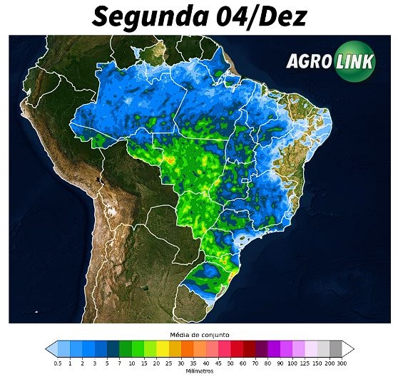
At the beginning of the week, quite extensive rains are forecast over Brazil, especially in the Northwest/South axis, covering a large part of the Center-West with the possibility of heavy rains.
Some areas of the country are expected to experience showers of up to 40 mm. The predicted configuration indicates the action of a cold front on the coast of the southern region, aligned with the humidity corridors leaving the tropical region.
In sectors with a greater presence of cloudiness, a reduction in maximum temperatures is expected, but heat will be the rule in much of the country.
The optimum temperature for soybean flowering is between 20 and 30°C, this stage being crucial for determining the productive potential of crops, which results in the formation of pods and, consequently, the quantity of grains per plant.
On the other hand, areas in the northeast of Brazil continue to experience firm weather, despite some isolated and temporary instabilities in sectors in the west of the region.

North region:
Rains migrate to the Center-South; North has dry weather
With the displacement of rain towards the center-south of the country, rain conditions decrease in much of the northern region. However, better distributed rains are expected over Acre, Rondônia, southern Pará and Tocantins. In these sectors, the greater presence of clouds should reduce maximum temperatures. In areas in the north of the northern region, such as Roraima, dry weather will predominate.
Northeast Region:
Moisture Corridors Impact Rain in the West of the Northeast
The presence of humidity corridors in the central region of Brazil should maintain conditions conducive to intense rainfall in parts of the western Northeast, especially in soybean growing areas in western Bahia, Maranhão and Piauí. In these areas, rainfall volumes are expected to vary between 5 and 15 mm, especially in the wetter regions. Despite this, areas in the east of the Northeast have lower chances of precipitation. If they occur, it is expected that they will be of low intensity and very short duration. Temperatures will remain high in all areas, accompanied by low relative humidity, particularly in the north of Piauí.
Midwest region:
Heavy rains forecast for MT and MS; Irregular Goiás
Well-distributed rains over the region are expected. This should guarantee voluminous and more widespread rainfall conditions over Mato Grosso and Mato Grosso do Sul, with accumulations varying between 20 and 40 mm. In Goiás, greater irregularity in these instabilities is expected. Regarding temperatures, rain helps to reduce the heat, therefore, keeping thermometers closer to 30°C in the afternoon, especially in sectors with greater chances of rain, such as the north of Mato Grosso do Sul and the central region of Mato Thick.
Southeast region:
Humidity corridors and summer patterns bring heavy rains in the Southeast
Humidity corridors continue to be active in the region, but it is the summer pattern that should guarantee rainy conditions over much of the Southeast. These rains can occur at any time of the day, with greater intensity and probability during the afternoon. However, despite the greater variation in cloudiness, high temperatures are expected in the region, which will result in a feeling of stuffiness.
South region:
Cold front brings rain and varied temperatures in the South
The presence of a cold front maintains rainy conditions in much of the southern region. Instabilities should be well distributed throughout the day, with volumes varying between 15 and 30 mm, on average projections. Occasionally, especially in the south of Santa Catarina and northeast of Rio Grande do Sul, these values can be exceeded. The dawn will be mild on the southern border and in the mountains of Santa Catarina, but the afternoon should have high temperatures, especially in the north of Paraná and western Santa Catarina, which could reinforce instability.
Source: Gabriel Rodrigues and Aline Merladete | agrolink


