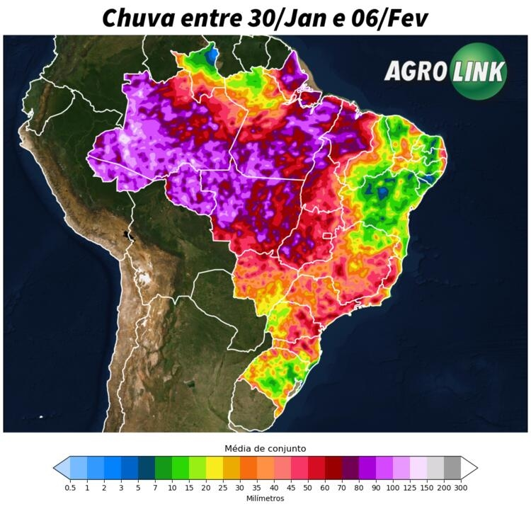
During this week, changes in the pattern of rainfall and temperatures are expected over the country. This must happen due to the weakening of the South Atlantic Convergence Zone (ZCAS) at the beginning of the period and the strengthening of a hot air mass over Argentina, Paraguay and the southern cone of Brazil.
Rains should be recurrent in areas of the North region, such as in AMACRO as well as in the northern half of Mato Grosso. In the Southeast region, although instabilities may be more recurrent, areas of western Paulista and Triângulo Mineiro should record very irregular rains, as well as in the south of Rio Grande do Sul.
Projections also point to a drier period in areas of Northern Bahia and Sealba; north of Roraima, Mato Grosso do Sul and Rio Grande do Sul. Where temperatures are expected to be higher throughout the period.
Changes in weather: Return of heat
The week starts with mild temperatures in the South, due to the influence of a polar air mass. In the Central-West and Southeast, a mass of hot and dry air raises temperatures, with peaks above 37ºC, especially in Mato Grosso do Sul and São Paulo and West of Rio Grande do Sul. In the Northeast, the hinterland is expected to face heat, while in the North, Boa Vista will have high temperatures due to less rainfall.

South
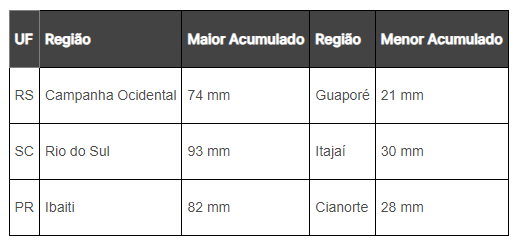
The formation of a low pressure system off the coast of the region should increase rainy conditions in the east of Santa Catarina and Paraná throughout the week. Low volumes are expected throughout the period, although some isolated thunderstorms may occur. Projections indicate drier weather over Rio Grande do Sul, in addition, greater warming is expected over the next few days, with thermometers approaching 38°C on Friday (02), in the southwest of Rio Grande do Sul. Low levels of humidity will accompany these temperatures, increasing the water demand of crops in the region.

Southeast
Heavy rains still persist over the region, with the largest accumulations concentrated in Minas Gerais, east of São Paulo and Rio de Janeiro, where up to 60 mm is expected. These rains can be intense in areas of Vale do Paraíba and Serra da Mantiqueira. However, only from Thursday (01) onwards will instabilities be more present in western Paulista and Triângulo Mineiro. Until then, conditions will continue with the predominance of a mass of hot, dry air. As soon as the humidity corridors move towards the south of the region, the north of Minas will once again experience drier weather conditions.

Midwest
Heavy rains are concentrated in the north of the region, especially at the beginning of the week, still under the influence of humidity corridors. Frequent rains and cloudy weather in the north of Mato Grosso and north of Goiás should keep temperatures lower for the season. A mass of hot, dry air will influence Mato Grosso do Sul next week, bringing firm weather in the south and very high temperatures above 40°C in the west. Despite this, at the weekend, areas of instability may advance to the south of Mato Grosso do Sul, bringing rain in the form of isolated thunderstorms.

North East
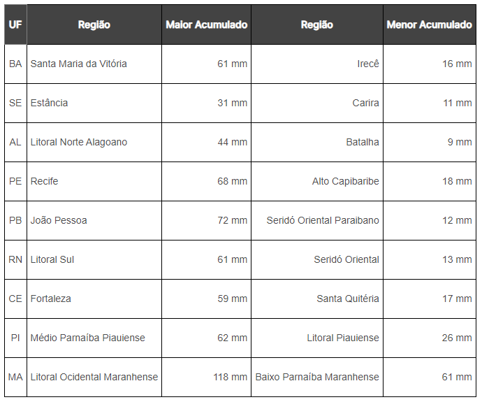
At the beginning of the week, rain is expected to occur in much of the region. However, the instabilities will lose intensity over the next few days, losing space to a mass of hotter and drier air. Therefore, rains are expected to be more recurrent in areas in the west of the northeast, such as in western Baiano, Maranhão and Piauí. At the end of the week, instabilities may be more recurrent in areas of the northern belt, although they present a behavior of isolated and temporary showers. As rainfall decreases, temperatures are expected to rise. In relation to crops, the reduction in instability should favor cultural practices and planting operations, which are still progressing in some areas.

Weather in the North
Tropical instability will be frequent in the region, especially due to the influence of the Intertropical Convergence Zone (ITCZ) in the north of Amapá and north of Pará. Rains concentrated in the west and southwest of the region, mainly in AMACRO, with a forecast of 150 mm during the period. In areas north of Roraima, the week will have a lack of rain. During the period, temperatures will be below average in the south due to frequent rains, while in the north temperatures will be above average.

Source: Gabriel Rodrigues | agrolink


